Nantes Université hires a post-doctoral fellow in remote sensing and carbon cycle for coastal area

Nantes Université is a public institution of higher education and research which proposes a unique model of university in France, uniting a university, a university hospital (CHU de Nantes), a technological research institute (IRT Jules Verne), a national research organisation (Inserm) and three « grandes écoles » (Centrale Nantes, Ecole des Beaux-Arts Nantes Saint-Nazaire, Ecole d'Architecture de Nantes).
These players are joining forces to develop the excellence of Nantes' research and to offer new training opportunities in all fields of knowledge.
Sustainable and open to the world, Nantes Université ensures that its students and staff have the best study, research and working conditions for their ongoing professional development on all Nantes Université’s campuses in Nantes, Saint-Nazaire and La Roche-sur-Yon.
Working environment and context
- Location: Nantes Université, Campus Science et Technologie, Laboratory ISOMer (Institut Des Substances et Organismes de la Mer - UR 2160)
As part of the European research project "REWRITE" (REWilding and Restoration of InterTidal
sediment Ecosystems for carbon sequestration, climate adaptation and
biodiversity support, https://rewriteproject.eu/), Nantes Université is recruiting a fulltime post-doctoral
follow for a 2-year contract (renewable 1 year), starting on April 2024.
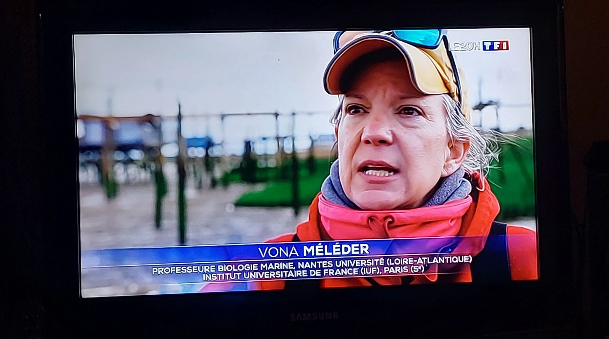
The post-holder will report to Vona Méléder, Professor in Marine Biology at Nantes Université and scientific coordinator of the “REWRITE” project. The "REWRITE" project will be carried out by a consortium of interdisciplinary, cross-sectoral and international partners, with the aim to contribute to a better understanding of coastal ecosystems composed of soft sediments: mudflats, seagrass meadows and salt marshes.
More specifically, it is dedicated to estimating their contribution to the carbon cycle (i.e. Blue Carbon), maintaining biodiversity and protecting against the sea level rise at local (ecosystem), regional (country) and global (north-south Europe and North America) scales, while meeting societal expectations (i.e. heritage, recreational and Blue Economy). Understanding the loss due to the retreat of these ecosystems, in terms of surface area and effectiveness in fixing carbon and maintaining biodiversity, will allow us to estimate the potential gain if these areas are restored and returned to nature.
Missions
The post-holder will lead an ambitious task within the Rewrite project to link carbon fluxes (Gross and Net Primary Production) and remote-sensing to map and project in time (time-series) and space up-scaling) the contribution of coastal ecosystems composed by soft sediments within the Global Carbon Budget (https://essd.copernicus.org/articles/15/5301/2023/). To reach this goal, the post-holder is expected to use images from existing archive (as Copernicus, Google Earth Engine, …) covering all Rewrite sites (https://rewriteproject.eu/demonstrator-network), as well as images acquired during dedicated synchronous field campaigns at various scales: laboratory, ground, drone, airborne and satellite; and using multispectral and hyperspectral technologies. A particular work will be done using a hyperspectral imager with the objective to map the ecophysiological and phenological status of the 3 key habitats. Theses maps, obtained at varied seasons, will be confronted to atmospheric CO2 fluxes measured in situ by Eddy-Covariance and/or incubating chambers to map fluxes at the scale of ecosystem.
This remote sensing task will be executed in combination with collaborator field investigations within several studies sites in Europe and North America, but also with other related remote sensing tasks (i.e ecosystem services connectivity; habitats; biodiversity) and modelling. In this aim, the post-holder, through being based in Nantes Université, will work with other post-doctoral fellows based at Twenty University (The Netherlands), Charokopio University (Greece) and Mont Allison University (Canada), but also with other partners within the project. The postdoctoral fellows will therefore participate in team-level publications on various topics on ecological structures, functions, and ecosystem services of these coastal area. The post-holder will be encouraged and mentored to develop additional related topics if he/she have ideas that will complement the overall project to promote his/her independent research and leadership.
Main activities
The post-holder will have to:
- Identify of the state-of-knowledge about the CO2 fluxes (GPP) for all Rewrite sites (existing data and their accessibility, missing data).
- Contribute to the implementation/design of new field investigations to fill the gaps of knowledge regarding CO2 fluxes and images acquisition.
- Establish algorithms using innovative approaches (multi-sensors, AI, …) for mapping CO2 fluxes (GPP) of these 3 key habitats within the Rewrite sites and produce time-series and maps.
- Develop additional related topics to complement the overall project.
Profile required
- Education and/or qualification: Ph.D. (or equivalent foreign degree) in Natural Sciences remote-sensing or coastal/ocean engineering, coastal oceanography, civil engineering or a related field. Candidates holding a Ph.D. in other disciplines, but with strong knowledge and skills relevant to remote sensing, are also welcome to apply. Ph.D. must be in hand at the time of initial appointment.
- Previous experience for the position: 3 years after PhD. Position open to agents likely to take advantage of a legal priority in accordance with the provisions of article 60 of the law of January 11, 1984 on statutory provisions relating to the State civil service (on presentation of proof).
Skills and knowledge required
General, theoretical or disciplinary knowledge
- Documented experience attesting to the job description above, including remote sensing and environmental data analysis (essential)
- Numerical modelling (desirable)
- Familiar with Google Earth Engine, Sentinel Hub, or similar remote platform (desirable)
- Familiar with hyperspectral data and imagery (desirable)
- Fluent English (essential)
Operational skills:
- Experience with programming languages (Python, Matlab, R, …).
- Experience with GIS and geospatial analysis.
- Experience with statistical modeling and analysis.
Soft skills:
- Ability to adapt: collaboration with a wide variety of partners
- Rigour and methodology
- Ability to summarise
- Ability to work in a team
- Autonomy
- Ability to take steps
Application requirement
All documents and materials must be submitted as PDFs and should be emailed to Vona Méléder: vona.meleder@univ-nantes.fr
Required Documents/Materials
• Curriculum Vitae:
Your most recently updated C.V. must include the names and contact information (email,
phone) of three references. The hiring unit will contact the references of those applicants who are under serious
consideration.
• Cover Letter:
Full consideration will be given to applications completed by March 20 2024. Applications received after this date will be considered only if the position has not been filled.
Prefered starting date: 1st April 2024
Contacts
Contact person for further information on the position: Vona Méléder: vona.meleder@univ-nantes.fr